Kazbek - route description
from Kazbegi (1740m) to Kazbek (5047m) summit - normal route

LOCATION
Kazbek lays on the border of Georgia and Russia, approximately 100 kilometres northwards from Tbilisi (capital of Georgia). GPS coordinates: N42.6972191, E44.5194485
START POINT
Startpoint of the climb is village Kazbegi (1730m), laying on an important road connecting Tbilisi and Vladikavkaz in Russia. Public transport from Tbilisi usually takes around 3 hours.
DIFFICULTY
The normal route from Georgia is not very demanding technically - comparable to average fourthousanders in f.e. Swiss Alps. Demanding is the overall lenght of the climb, height difference (start point is only at 1730m) and of course the summit height of over 5000m. What can make the climb really strenuous is weather, which changes here very fast and lot of people fail to summit the mountain because of that. Overall grade of the normal route is PD (sometimes also graded PD+).
GEAR
Under usual summer conditions, the standard glacier gear is enough to handle the climb - crampons, ice axe, rope, harness... A warm, windproof clothes is a must - the mountain is a lone stander and attracts gale winds, which can pull the temperature below -20C, even on a sunny summer day. Trekking poles and ski goggles makes sense to carry (as protection from blown volcano dust around the Khmaura Wall, strong wind on the glacier...). Ice screws would make sense to use only for the final steep slope (40 - 45 deg) below the summit - but the summer would have to be super hot to have the snow melted up there (we've been here in September, summer was warm and only few small spots with blank ice).
WEATHER
Forecast for Kazbek Peak: http://www.mountain-forecast.com/peaks/Kazbek/forecasts/5047
Alternatively you can use forecast for village Pasanauri, which lays some 50 km to the south from Kazbek: http://www.weatheronline.co.uk/Georgia/Pasanauri.htm
WATER
Potable water is rather scarce along the normal route. There is a spring next to the Tsminda Sameba Church (2190m), further there should be water source near camping place (2990m) behind Arsha Pass (however, in September 2012 we did not find any water source here). In the Base Camp at 3670m was possible to get water from a nearby ice field (boil the water or use water purifier). Alternatively, the hut warden sells bottles of water - 10 GEL / litre. Above the BC, glacier, snow and gas stove are your friends.
CLIMB ITINERARY
There are tons of options how to handle the climb via the normal route, but if you are not acclimatized, count with at least 4 full days to get to the summit and back to Kazbegi. Considering the relatively often bad weather, add another 1 or 2 days as a reserve. Below couple of usual itineraries.
Option I
1. day: afternoon walk-up from Kazbegi (1730m) to Tsminda Sameba Church (2170m), overnight in tent near the church
2. day: walk to the Base Camp (3670m), overnight in tent
3. day: move to the Advanced Base Camp (3860m), acclimatization walk-up, overnight in tent in ABC
4. day: climb the summit (5047m) and descent to the BC, overnight
5. day: descent down to Kazbegi
Option II
1. day: morning start from Kazbegi (1730m) and long day ascent to the Base Camp (3670m)
2. day: acclimatization to 4200m, overnight in the BC
3. day: climb to the summit (5047m) and return to BC
4. day: walk down to Kazbegi
Option III
1. day: afternoon walk-up from Kazbegi (1730m) to Tsminda Sameba Church (2170m), overnight in tent
2. day: walk to the Base Camp (3670m), overnight
3. day: move to the C1 (4320m), overnight in tent on the glacier
4. day: climb the summit (5047m) and descent to camp site (2990m) below Gergeti Glacier
5. day: descent to Kazbegi
In general you have 3 possible start points on the summit day:
- Base Camp around the former Meteostation (today Bethlemi Hut), 3670m
- Advanced Base Camp (plateau with couple of places for tent), 3860m
- C1 (camp below the Kazbek Pass, tenting on a glacier), 4320m
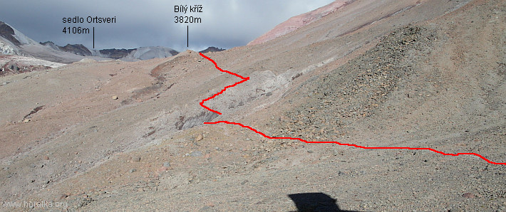
ROUTE DESCRIPTION
from Kazbegi (1730m) to Tsminda Sameba Church (2170m)
- height difference: 450m, time: 1hr 30min to 2hrs
- on the crossroad behind the main square in Kazbegi take the left road and walk down to a bridge
- cross the bridge (lowest point of the whole route – 1730m) follow a dust road up the hill to Gergeti village
- the village is passed thru it's left part, in the upper left part one leaves the village and follows a steep path
- after short, but steep walk up, the path enters a wood and later joins an 4x4 road leading to the Sameba Church
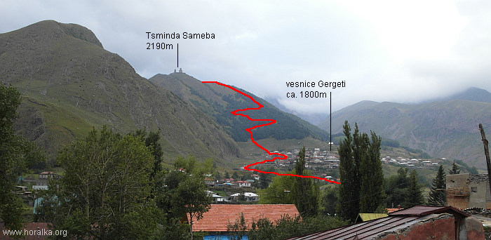
walk-up from Kazbegi to Tsminda Sameba Church
- it's possible to follow the dirt road whole way up to the church (not steep, but long)
- follow the much shorter, but steep path
- prior the last zig-zag the road goes for a very long way very gently up
- it's better to take a path directly upwards, thru a birch wood to the plateau near the church
from Tsminda Sameba Church (2170m) to Arsha Pass (2940m)
- height difference: 790m, time: 2hrs až 2hrs 30mins
- first 15 minutes walk from the plateau leads thru birch wood to minor peak on the ridge leading to the Arsha Pass
- walk gently further up for app. 10 mins on the ridge
- the path then turns to the left and traverses steep grassy slope
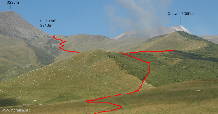
from Tsminda Sameba Church to Arsha Pass
- further up to the pass it's mixed walk over grassy slopes and steeper sections
- the terrain is steeper above 2800m
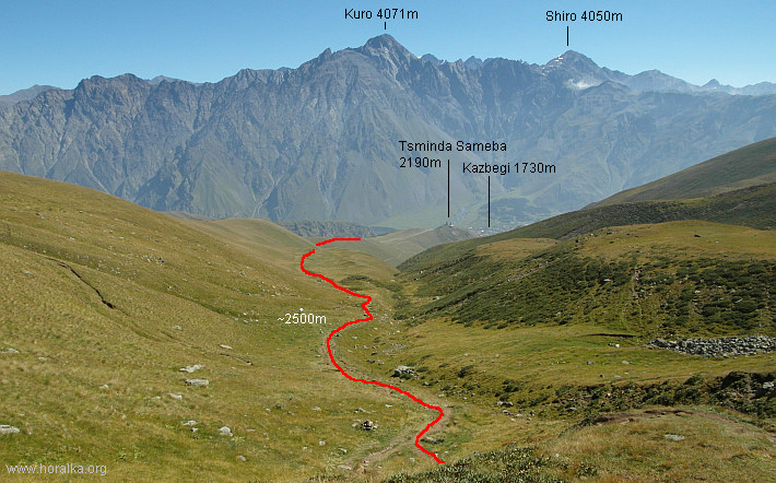
looking back from app. 2500m...
...and up to the saddle
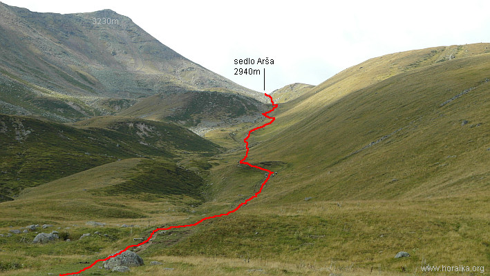
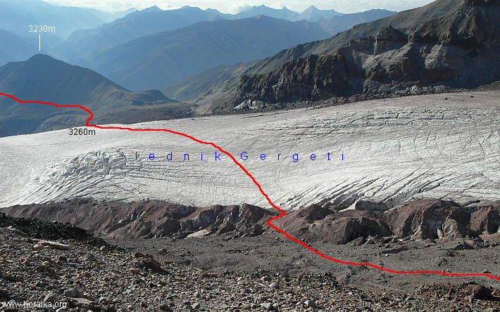
from Arsha Pass (2940m) to Gergeti Glacier (3260m)
- height difference: 400m, time: 1hr 30mins to 2hrs
- first you will loose some 100 height meters and descend from the pass to grassy plateau
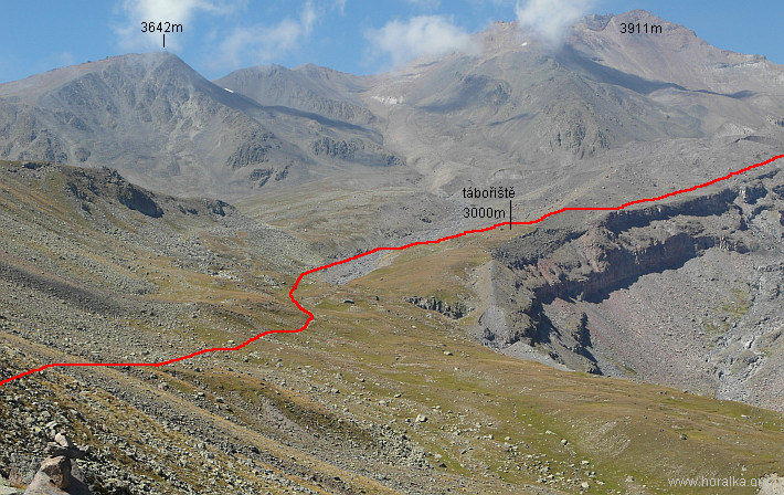
first 2/3 of way to the glacier
and view back from the moraine to the pass
- follows short gently ascending walk to a glacier stream
- depending on year's period, respectively day period varies the difficulty of crossing the stream
- everything between walk through to long and high jumps is possible
- right past the stream is a nice tent place (2990m)
- reportedly water source is somewhere nearby, but we did not find anything
further towards the glacier and BC
- further you walk over the glacier moraine, thru stony terrain up to beginning of the Gergeti Glacier (keep rather right on the moraine)
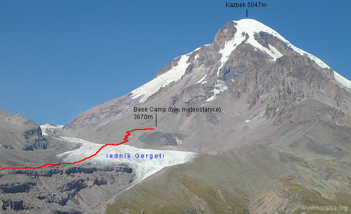
over Gergeti Glacier to Base Camp – former Meteostation (3670m)
- height difference: 410m, time: 1hr 30mins tož 2hrs
- on the glacier keep walking directly against the contour lines up to app. 3400m
- then divert to the right and in lightly ascending traverse lead to place marked with flag
last stretch prior BC
- past the flag you leave the "white glacier" and step on the "dark glacier"
- follows a steeper walk-up over scree to the Base Camp at 3670m
looking back on the way over glacier
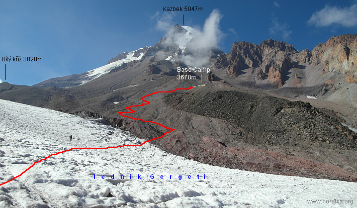
from Base Camp (3670m) to Advanced Base Camp (3860m)
- height difference: 250m, time: 40mins to 1hr
- the path starts with slightly descending traverse over stones and scree
- further ascending over glacier covered with stones to minor peak with white cross on the top (3820m)
- then gently up to rocky plateau with tent spots (3860m)
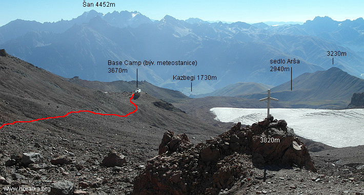
first section of ascent between BC and ABC
from Advanced Base Camp (3860m) to C1 (4320m)
- height difference: 500m, time: 2hrs 30mins to 3hrs
- first stretch leads over scree, passing small black cross (3900m) and ascending to the beginning of "white" glacier
- after few hundred meters long traverse you get back to scree and rocky terrain
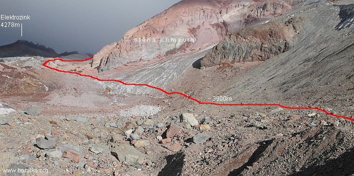
part of the climb from ABC up to Khmaura wall
leg from BC up to the White Cross
- follows a hard to describe section
– labyrinth made of big to huge crevasses on a glacier covered with boulders, stones, sand and mud
- all that is below the Khmaura wall, which sends down stones and boulders almost non-stop
- and some of them stop their journey pretty close to the trail
- the path apparently changes every year here, because the glacier and crevasses change
- there is half a dozen of paths in the labyrinth, but most of are blind - cut with a crevasse
- if you will be hitting the summit from BC or ABC, it's more than wise to check this section the day before summit day
- above app. 4100m the terrain is more "user friendly"
- between 4150m and 4200m, the last part below the Khmaura Wall (before you get below huge serac on your right), is needed (at least we were forced to do so, to bypass huge crevasses) to get pretty close below the wall and especially in the afternoon there is very high risk of being hit by the falling stones
- one enters the white glacier at 4220m
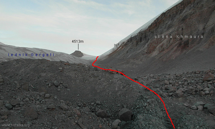
last stretch under the Khmaura Wall, ca. 4150m
- walking-up gently over the glacier (some crevasses) you get to plateau below the Kazbek Pass
- the plateau is used as C1 (4320m)
- it is bit covered from the strong winds, which usually blow up in the Kazbek pass
from C1 (4320m) to Kazbek summit (5047m)
- height difference: 730m, time: 3hrs až 4hrs
- walking up the right slope above the plateau (few crevasses on the way) you get quickly to the wide Kazbek Pass (4480m)
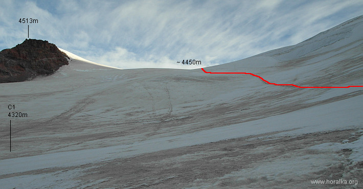
trail from C1 to Kazbek Pass (4450m)
from the plateau to edge at 4600m
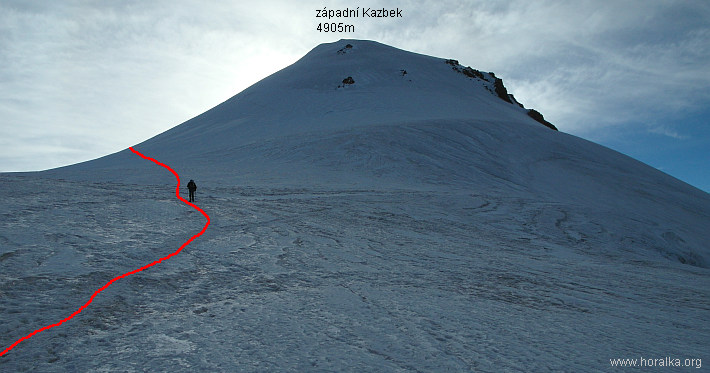
- the trail turns more to the right and leads to a glacier edge running from the western Kazbek summit
- on the edge you are (illegally) entering Russian territory and in the same, it's getting steeper
- below the col between main and western Kazbek summit the path returns in one zig-zag and you get to the col from the right side
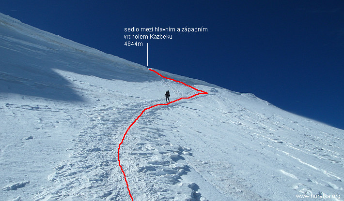
last steep part below the saddle (4844m)
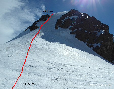
steep slope (45 deg) from the col to the main summit
- from the saddle (4844m) follows the steepest part of the whole climb
– steep slope (150 height meters, up to 45 deg), often icy
- the very very last leg is gentle walk over the summit dome
- if you are lucky, you can enjoy magnificent view over large part of Caucasus (Elbrus, Dych Tau, Skhhara...) and on the southern horizon maybe even Ararat in Turkey
|
vedlejší ulice;
počasí v alpách sněžnice english deutsch co a kdy jsem vylezl plánované akce |
odkazy; phototravels - fotky z cest miloš růžička - horské praktikum výměna odkazů |
navigace; nahoru zpět |
horalka.org; podmínky použití kontakt |